
information collection tool for hurricane relief
Project Dawn
UX Design Studio 1 | Fall 2017
Tools used: Invision, Sketch, Principle, Adobe Creative Suite, Unity, Framer.js
This project was published in the Extended Abstracts of the 2018 CHI Conference on Human Factors in Computing Systems. View the full paper here:
Natural disasters affect everyone.
While there is a vast amount of information out there, the facts are not always presented in a manner that effectively and efficiently informs citizens of what will happen to them on an individual level. Information noise can cause both confusion and misdirection on regarding their response to natural disasters.
Over a billion people in the world live in low-lying coastal regions. Hurricanes in particular present a huge threat to the world as they form only over warm ocean waters near the equator. As ocean temperature levels rise, hurricanes will only get more powerful.
1. Hyperlocal Adaptive Forecasts
Project Dawn is a local weather information platform that improves the process of communication and recovery for hurricanes for citizens and local governments.
Dawn is comprised of two key systems that interact closely with each other.
Process
Providing citizens with hyperlocal weather information presented in an easily understandable manner through CUI-style alerts that streamline weather forecasts.
This gives citizens personalized information before, during, and after the hurricane regarding aspects like evacuation likelihood and risk assessment.


Information given through multiple platforms.
Web application, Google Home or other VUI platforms, SMS, Social Media.
Comprehensive Storm Visualization
Storm predictions without any confusing terminology. Translating data from multiple sources to personal, meaningful, and easily understandable direction.
2. Augmented Situational Awareness through Drone Swarm Surveillance
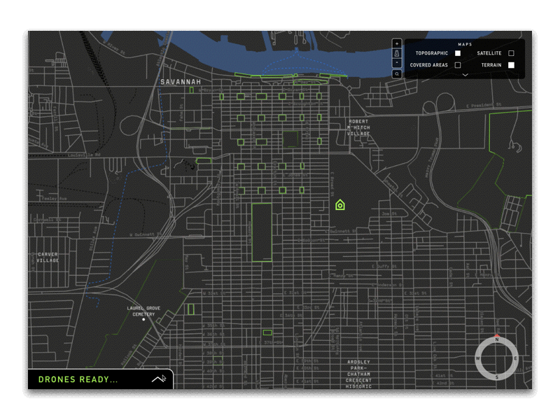
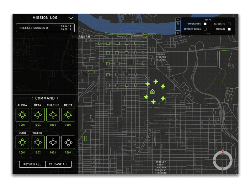
Drone swarms are released by local EMA operators before and after the hurricane to assess risk pre-storm and evaluate damages post-storm on individual properties throughout the city. This information is stored in a database that the hyperlocal forecasts are sourcing from to provide citizens with personalized information.
Utilizing drone swarm surveillance operations to efficiently assess damages on a large scale to be sent to FEMA for accelerated relief distribution to the city.
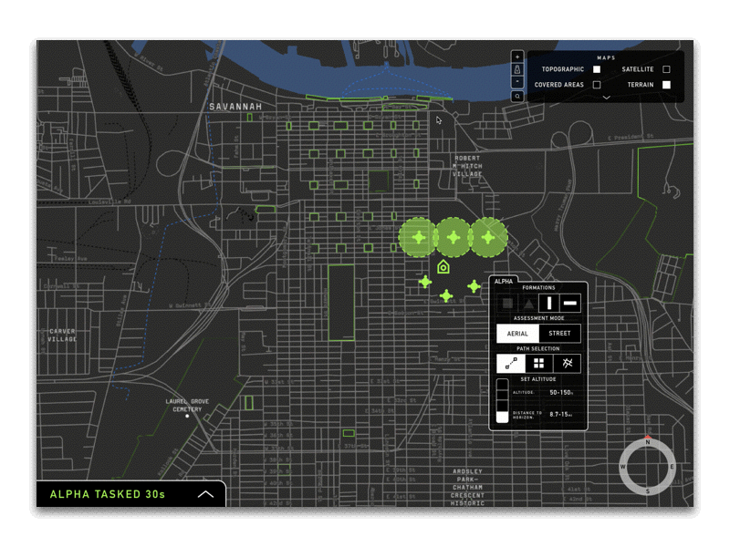
Assess pre-storm risk, identify post-storm damage costs and hazards.

Why?
Weather-related disasters have the potential to cause devastating impact on community infrastructure, families, and lives.
The current state of hurricane relief can be broken down into pre-hurricane preparation and post-hurricane recovery. Several problems exist in both stages of overall hurricane relief from both the citizen and government perspective; these range from the ambiguous and confusing information experience regarding storm preparation, to unoptimized relief protocols for infrastructure damage.
Who?
Marginalized Citizens, Local Government EMA specialists, and Citizens connected with technology.
Optimizing hurricane preparation, evacuation, and relief is crucial to those living in areas with frequent tropical storms. Those who live in coastal regions understand how much impact a hurricane can have on all aspects of one’s life.
What?
Dawn: Augmenting situational awareness on both the citizen and government sides for faster hurricane relief.
Local EMA (Emergency Management Agency) specialists will release drone swarms days before the storm is projected to hit to assess analyze risk analysis on individual properties and key buildings. The analysis utilizes computer vision to identify structures and materials that have high risk of damage (based on various factors such as water levels, structural stability, electric danger, elevation, etc), and an individual risk analysis is generated per property.
Citizens can search for their specific home on the risk assessment web application and get personal details on the types of damages they may encounter, as well as suggestions on whether or not they should evacuate. This condenses large amounts of confusing weather information into bite-sized, hyperlocal information given on an individual level.
For marginalized citizens who may not have a means to evacuate, a web-based platform is provided in order to match evacuees together. Volunteers who help evacuate citizens are allowed to access priority lanes in a more streamlined evacuation experience.
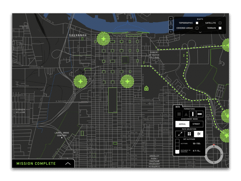
Drone swarms are released again by EMAs, this time to identify hazards and evaluate damages. As soon as these costs are calculated, the information is sent to FEMA to receive relief and begin repairing the city’s infrastructure; the key to relief lies in the fastest way to accurately assess property damage.
Evacuated citizens are able to view the status of their house from the drone footage that is uploaded onto the web application so they are able to know when they will be able to return and what they should prepare.
Pre-storm
Post-storm
The time saved by utilizing drone swarm surveillance for large-scale assessment will expedite the process of receiving relief from the federal level (Federal Emergency Management Agency) to the city greatly.
 |  |
|---|---|
 |  |
 |  |
 |  |
 |
Team
Research Process
Problem Space Exploration

Concept Synthesis
This project was created over the course of 9 weeks in my UX Design Studio 1 class. The nature of the work environment in this class was extremely malleable, and we consistently moved between groups and teams in order to best tackle the job at hand. At around week 5, we diverged into three teams to target our three key problem spaces. While we all continued to work closely together, at this point my team focused on the drone swarm surveillance operation system to be used by local government EMAs.
Jenn Lee
Production Manager
UX Designer
Delivered:
Primary research, secondary research, concept development, user journeys, low-fi/hi-fi wireframes, prototypes, system navigation, team management, case study content strategy
Oscar Kwong
UX Design
Delivered:
Primary research, secondary research, concept development, user journeys, low-fi/mid-fi/mid-fi/hi-fi wireframes, system navigation
Jonathan Tucker
UX Design
Delivered:
Primary research, secondary research, concept development, user journeys, low-fi/mid-fi/mid-fi/hi-fi wireframes, system navigation


 |  |
|---|---|
 |
 |  |
|---|---|
|  |


How might we create flexible evacuation options for every user in the income spectrum?
How might we lessen the time it takes for cities to receive federal aid for damages after a hurricane?
How might we provide more accurate and trustful information according to evolving situations?
Personas
 |  |
|---|---|
 |
Design Process
User Testing

As we continued to develop our design concept, we visited the Chatnam Emergency Management Agency (CEMA) in order to get usability feedback on a few information retrieval operation prototypes as well as validation of the feasibility and practicality of our concept. The EMA specialists we spoke to were given small tasks to operate the interface and talk through their opinions.
